Monday, November 10, 2008
Class 10
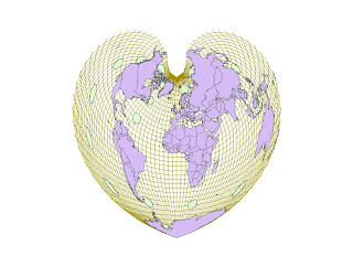
These images were from the exercises out of the Mastering GIS book, dealing with drawing and symbolizing features. Cool stuff. The more I learn, the more I want to learn :)
Sunday, October 26, 2008
Bike Map
I have spent an absolutely inordinate amount of time on this map!!! However, the road bike routes in Buncombe County are especially of interest to me, and I can see myself looking at this map in the future to check out roads, mountain peaks, etc. I still feel lacking in knowledge of how to get labels to curve with features, so I'm going to spend the next bit of time learning about that. So much to learn!! But god knows, I can start working on a map, and look at my watch and 3 hours have gone by! Whew!!! It's really fun... :)
Tuesday, October 14, 2008
Second Printing - Asheville Bike Routes Map
This is the version I am showing to the class. I find it very difficult to say "I'm done". But I'm done enough today to show this map to the class. A did a little bit of splining of labels; never did get to do any drop shadows, but overall I pretty happy with this map. I think it's attractively designed. I think I have a knack for the design part. Now I just need the memory to remember how I have done things, or how Pete has demonstrated things. That's harder for me. I need another 1G memory chip! :)
Tuesday, September 30, 2008
Tuesday, September 23, 2008
Bike Map
Wow. This is hard. I'm just now getting a clue of how much there is to learn with this technology...
I was proud at least when I figured out how to show to degrees of "ridability" of the various bike routes - from heavily to lightly trafficked roads...
I was proud at least when I figured out how to show to degrees of "ridability" of the various bike routes - from heavily to lightly trafficked roads...
Sunday, September 14, 2008
Bike Map
This is a great assignment, since I am a member of the Blue Ridge Bicycle Club, and I LOVE riding. Most road cycling these days, although I was on my mountain bike at Bent Creek 2 days ago.
I've been talking with Claudia Nix, co-owner of Liberty Bikes, and an ACTIVE member of the BRBC. We've been discussing the club's current "Bicycle Transportation Map", and the brand new map that is at the printer right now.
The club has even more ideas about what the next map might have that the new one doesn't have. In the future this might be a way for me to help out the club, and cyclists in Asheville in general...Tuesday, August 26, 2008
Chapter 1
Cool to find out tonight that links to "Jobs" and "Internships" are on Pete's (sorry, I mean, Professor Kennedy's) geospatialtechnology blog. I WILL be checking those out...
Monday, May 5, 2008
Saturday, May 3, 2008
Sunday, April 20, 2008
Module 10, Hands-On test
I had the most fun with the Hands-on test, since up until then we had just been following along in the book, and not creating anything from scratch. So it was neat to find out if I could remember how to clip, how to select by location and attribute, etc. I am getting a little bit more comfortable with the Arc software; I don't feel quite as lost as I did at first.
Then, of course, the Spatial/Terrain Analysis is very cool...
Then, of course, the Spatial/Terrain Analysis is very cool...
Sunday, April 13, 2008
Thursday, April 10, 2008
Sunday, March 16, 2008
Saturday, March 15, 2008
Week 7
Video on Editing Tips and Tricks Thurs. night. Helpful hints.
I find myself a little overwhelmed sometimes with all the new terminology, and menus, and options, and joins, and relates, and on and on. It's easy to do an exercise step by step, and feel like I understand what I'm doing. But I've started thinking about the final project, and what I might like to do, and wonder if I will remember very much about the steps I took in each chapter to compare/contrast/analyse information, layers. I feel like it wouldn't hurt me at all to go back and do all the hands-on exercises again!?! Too bad I have to work for living! It keeps getting in the way of doing the things I'd rather be doing...
I find myself a little overwhelmed sometimes with all the new terminology, and menus, and options, and joins, and relates, and on and on. It's easy to do an exercise step by step, and feel like I understand what I'm doing. But I've started thinking about the final project, and what I might like to do, and wonder if I will remember very much about the steps I took in each chapter to compare/contrast/analyse information, layers. I feel like it wouldn't hurt me at all to go back and do all the hands-on exercises again!?! Too bad I have to work for living! It keeps getting in the way of doing the things I'd rather be doing...
Thursday, March 13, 2008
Thursday, March 6, 2008
Week 6
We had a lecture on Remote Sensing Data tonight - aerial and satellite imagery. Then worked in lab on Ch. 8 - Querying Data. Also saw photos on Valladolid, MX. The Mayan "ruins" are SO COOL... I really have to go there and see those. I've been fascinated with them for a long time.
Sunday, February 24, 2008
Week 5
Studying today, for last and next week. I'm going to Charleston, SC with the Blue Ridge Bicycle Club next weekend (never been to Charleston!!), to do several organized rides, and eat the wonderful food! I got a condo right on the ocean!! - Isle of Palms. Gretchen is going with me... I probably won't want to study a whole lot while I'm there :). So today is GIS day...
Week 4
Test week - had to really study... So many new terms!! But still having alot of fun with this class :)
Thursday, February 7, 2008
Week 3
The graphic design part of this lesson is the most fun to me of all of it, maybe. I have also been wanting to take a computer art class for a while now. So I really like that graphic design is a piece of what we will be doing...
Monday, February 4, 2008
Week 2
I am REALLY enjoying this class. It seems like GIS combines the "geeky" aspects with which I am already fairly confortable with other aspects of IT that I have been wanting to learn more about: database management, a tiny bit of programming (object-oriented), and, of course, graphic design.
Thursday, January 31, 2008
Thursday, January 24, 2008
Subscribe to:
Comments (Atom)


